Log In
/-79.471750259399,33.071692454303,12/500x250?access_token=pk.eyJ1Ijoid2F0ZXJ3YXlndWlkZSIsImEiOiJGRmM1RDdzIn0.Wya5yV5QEqbz0-fct8zyIA)
SC: McClellanville MM 431
- Date Reported: Jun 30, 2025
- Reporter: Bob423
- Source: User
- Description:
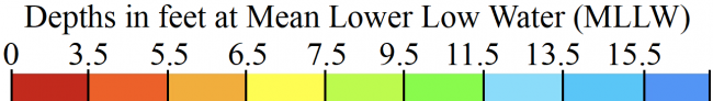
Update: 5.3 MLLW as of 6/17/2025 on the Bob423 track.
McClellanville was dredged to 12 MLLW from R35 to G43 but has shoaled. Jeremy Creek, leading to McClellanville, has been dredged to 10 MLLW but has also started to shoal again. The 11/8/2024 USACE survey is shown in Aqua Map with the Bob423 Track. The passage is very narrow for the deepest water, only about 30 feet wide before losing 0.5 to 1.0 feet of depth off the Bob423 track.

The shallowest part of the passage was here, at MM 430.9, at 4.9 MLLW. Stay on the Bob423 track, it's only 30 feet wide.

It is very hard to judge distances to a marker. Here, the best water is 143 feet off G39. Too close and too far finds shallow water. Just follow the Bob423 track.

USACE = US Army Corps of Engineers
ATONs = Aids TO Navigation such as buoys and daymarks
Aqua Map = a navigation app for Apple and Android devices
Bob423 Long Track = blue dotted line
How to download tracks - Lat / Lon: N 33° 04.302' / W 079° 28.305'
DISCLAIMER: Waterway Guide Media provides Navigation Alerts as a resource for planning purposes only and does not warrant the information included in the postings as accurate. Advice and descriptions contained in the alerts are not for navigation.
3 Boater Comments
-
Comment by: Kevin Ho on Jun 13, 2025
Vessel Type: Sail
LOA: 31'
Draft: 5.0'Went through on 3ft tide, 8.8ft at controlling point exactly on Bob423 track
View location on the Waterway Guide Explorer
-
Comment by: Elizabeth Lenoski, Tranquilo, on May 16, 2024
Vessel Type: Sail
LOA: 36'
Draft: 5.0'At shoal saw 6' at 2.5' tide
View location on the Waterway Guide Explorer
-
Comment by: Teresa Scott on May 7, 2024
Vessel Type: Sail
LOA: 40'
Draft: 5.5'Came through at mid tide and ran aground in 5 feet. Found deeper water 7 ft on west side of channel but still have to watch for shoals.
View location on the Waterway Guide Explorer