I'll cover the changes to the Atlantic ICW since the last Bulletin. Be sure to see all the spring Bulletins for an overview of changes this spring.
1 - MM 731 Sawpit Creek has been dredged. The dredged route goes straight through for 12 MLLW, just honor the ATONs. Note: the ATONs do not match your chart. See the minchart below for the correct placement of ATONs. Just so you would not be surprised, I show the new route as a blue dotted line against the old USACE survey, since the new survey showing the dredged channel is not yet in Aqua Map. The most recent dredging has removed all the red around the blue line.
Sawpit Creek is one area that shoals the same way year after year, leaving the path shown by the red dotted line as a dependable detour for 7.5 MLLW when shoaling blocks the NOAA channel. With that in mind, I left the detour in place since the main channel will shoal again within 1 to 2 years. For now, the blue dotted line is good for 12 MLLW so take the straight route, it's shorter. Check with the Waterway Guide Alert for Sawpit Creek for the current state of shoaling to see which path to take.

2 - MM 729 South Amelia River at Nassau River has been dredged. The Bob423 track (blue line) follows the newly dredged path, the official NOAA channel. It appears to go straight into shoal water, but the survey is before dredging, and it's actually 11 MLLW. I purposely used the old survey for illustration since that's what you'll see in Aqua Map when following the Bob423 track. The new survey is not yet in Aqua Map, and won't be for several weeks; I have an advanced copy.
This is another area that shoals the same way every time. The red dotted line shows a way around future shoaling for 11 MLLW, a detour to be used when the NOAA channel is once again shoaled in 1 to 2 years. The detour path has never shoaled beyond 11 MLLW, but it's longer. Check with the Waterway Guide Alert for South Amelia River for the current state of shoaling to see which path to take. 
3 - MM 329 Shallotte. R81 is sitting in a shoal. Follow the Bob423 track for 9.7 MLLW as of 3/21/2025. The Coast Guard may move G81 next week or later to direct boaters away from the encroaching shoal. Regardless, the Bob423 track shows the deep water path. 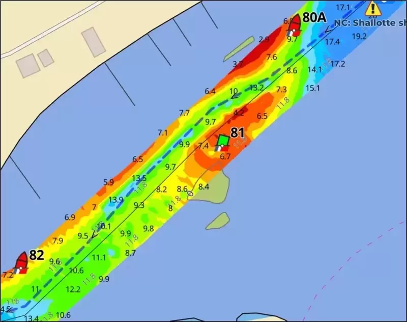
4 - MM 7.5 (north end) Dismal Swamp. The Dismal Swamp Canal should be on everyone's list for ICW cruising at least once. Unfortunately, it's been closed this year for repairs to the Deep Creek Bridge at the north end. The good news is that the repairs are on schedule to be completed by 5/5/2025. Before committing to the route, be sure to call 757-487-0831 to be sure the bridge is operational. While you're at it, ask the lockmaster if the canal has been verified clear of debris. It's been almost half a year since anyone has been through, and you don't want to be the first boat. Elizabeth City will be thrilled to see cruisers return to their free docks.
The Ft Pierce A1A bridge at MM 964.8 and the Onslow Bridge at MM 240.6 are still under construction schedules until 5/2/2025. See last week's Bulletin for details.

Use Waterway Guide Alerts to plan your trip, adjusting timing for the tide you need. Follow the Bob423 tracks in Aqua Map to ensure you get the maximum depth possible. The color-coded depth charts are from USACE surveys in Aqua Map. The areas mentioned in this Bulletin are only the recent changes, not a complete guide to all shoaling. Additional resources are available in the Waterway Guide digital publication 2024 ICW Cruising Guide and at Bob423 Guides.
General information on the attractions of America's waterways can be found at Waterway Guide's webpage. Additional publications on all regions can be found at the Ship Store. Many helpful articles are available in the Knowledge Center. Explore the Waterway Site for a wide range of help in your cruising adventures.

- 4,000 Marinas
- Thousands of anchorages
- Updated Charts
- Mile-by-Mile Navigation
- Highlighted Alerts & Cautions
- Full-Color Aerial Photographs

The Waterway Guide App Makes it easy to leave reviews, use our explorer, and view waterway guide materials all on the go!